
Wilderness backpacking in Lomsdal-Visten National Park
- Marius Karlsson

- 24. aug. 2025
- 11 min læsning

Last summer, I spent around 15 days in Lomsdal-Visten National Park, hiking, bushwhacking, camping, and fishing. And while doing that we met no other people, that's a big plus in my book, and actually one of the reasons we went there!
To start off, this area is quite remote (by Scandinavian standards), so it's essential to know what you're doing before you begin hiking here. The terrain can be particularly challenging, and it can take multiple days to get out if you become stuck in the middle. Trust me.
Lets talk about the trip now. It all began in Denmark, where I was searching for where to go next after 3 weeks crossing Europe's last wilderness, and I wanted more wilderness! So, scouring Google Earth and TOPO maps like UT.no, I ended up finding Lomsdal-visten. There is very little on the internet about this place, except on the national parks own website. So you really have to find it by looking at a map. But that is perfect! If it's not known about on the internet or by the Norwegians, then I will have it all for myself. So after finding some people who wanted to go and getting everything ready, we flew to Brønnøysund. Unfortunately we had problems with the baggage and one guy got sick, so he had to fly home... But after some unlucky days our trip finally started!
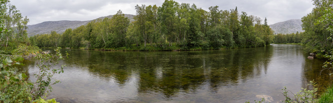
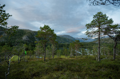
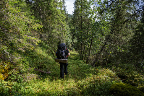
We began in the south of the national park at Bekkelia, where we were dropped of by a nice local. We began the unwanted but necessary climb up the mountain to get to the national park border and our first camp at Bjørnstokkvatnan. It was a beatiful start with great views over the fjord and into the national park. We even came by a nice waterfall.


Photos from our hike up to the first camp.
The trail was nice for the first part, but then we came into boulder fields, and the trail just got less and less visible. But that is the reason we are here, to trek in the wilderness not on prepared trails!

After some slippery and at times pretty difficult rock sections, especially when you are tired at the end of the day, we ended up at out first campsite. This day we did not fish, but we will get our revenge later in the tour.


First camp
The plan on day 2 was to get as close to Lomsdalen as possible, and maybe even down in it. Not longer after beginning day 2 the "trail" we followed completely disappeared, and a little later we stood in front of a steep mountain we had to get over. Once we got over, we had a view of Øvre and Midtre Breivatnet. Then we just had a steep and slippery downhill, and it looked like smooth sailing from here, which it was not.


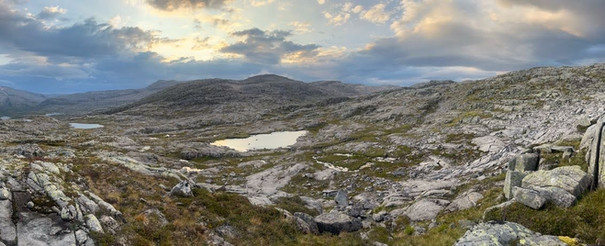
Trip down to Nedre Breivatnet
Getting past the two big lakes was pretty easy, but then it began to rain, making our walk along the steep slope above Nedre Lappskardvatnet a bit more difficult than some of us liked. But hey, we got rewarded with the view of the first animals of the trip - a small herd of reindeer! And the view down to Nedre Breivatnet, our goal for today.
We had one very big and a little risky obstacle that day, it was the Breivasselva. I had read about on the internet beforehand, Sometimes if it rains a lot it is unpassable, but other times it is possible to ford. Well I for sure did not want to walk all the way around the lake and loose nearly a day of hiking this early on, as there are many places where we might need to take a longer route to come, so we really hoped that it was crossable.
Well, we reached the river. Usually, you cross in the widest place, but in this case, it meant swimming, so we decided for a narrower spot, with a lot of current but not that deep water, "only" reaching our noble parts. However, the crossing was quite challenging due to the powerful current and large, slippery rocks. We even experienced a fall, which fortunately ended without incident. My reasoning was that the wide, calm area was just beyond this spot, so if the river swept us away, we could easily swim to the shore there.

Here I am out helping break the current to make it easier for my friend to cross, also I can help him if he falls.
We all made it to the other side. But we were very wet and cold, because it took a long time in the freezing cold water to get to the other side. Now it was time to find a campsite, cook some food, regain warmth and sleep.
Next day was short, to get a semi-rest day and time for fishing. We went down from Nedre Breivatnet and got view of the very beatiful Lomsdalen full of small lakes and the Lomsdalselva (river) all contained by mountains all around.


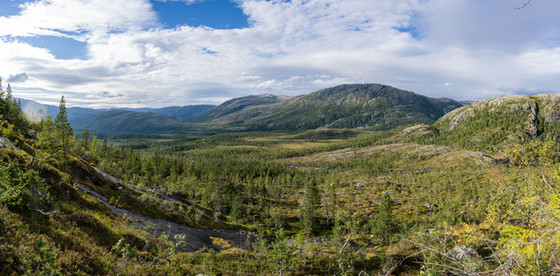
Going down and through Lomsdalen to Dyrbertjønna
When we finally reached our destination, after a hike that took a bit longer than expected, we went on with relaxing and fishing a bit in the evening.


Camping and fishing in Lomsdalen
Unfortunately, we had no luck with the fish, but the beautiful surroundings made up for it!
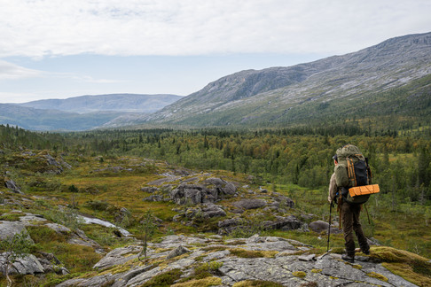
Next day was very long, I decided we should try a small shortcut trek up to Geehpjaevrie instead of trekking the route to Visttindan. It was not the best idea, but fun to try new things! We started off hiking through Lomsdalen, where we crossed the only bridge (?) in the national park over Nedre Grunnvasselva. We continued towards Henriksdalen, which brought along a decent climb, but also a good view of Henriksdalen, our next challenge.
Henriksdalen ended up not being that challenging, but the climb up to Geehpjaevrie... Oh my god. We turned "off" Henriksdalen at lake 388 and began climbing towards Geehpjaevrie, turns out those very close together brown lines on the map actually means its steep - who would have thought! It was hard but not dangerous, until we met a pretty much vertical and at least 10-15 meter high cliff wall, which was something of a climb with my 30 kg backpack. So trekking poles were stowed away and hands were used; the climb really got some adrenaline going, and in my head I was thinking what I would do if one of us fell... But slow and steady won the race and we got up safe and sound. Unfortunately, I was all focused on the climb and it was too dangerous to get the camera out while climbing, so no photos...


A very long day, trekking all the way to Geehpjaevrie - a route I have not heard about anyone doing before
Finally we got up late in the evening and got our tents up. The weather forecast said rain all next day, so we decided to have a rest day up here. It was quite a windy night, but no problem for my Hilleberg Allak 2.


Camp at Geehpjaevrie
Again we tried fishing here, but no luck... What is going on? We where promised sublime fishing waters, well maybe this was to barren. Fortunately I had brought along my homemade dried food.
After a nice rest day we had a difficult decision, it was good weather now, but bad weather was forecasted for the long time after, according to my sattelite phone, and the climb down to Sæterdalen from Sæterskardet was steep, and doing that with wet rocks and high winds, well, that did not sound very nice. So we had to find a way down that we could do in one day, while it was still good weather, the decision fell on the descent to Blankvatnet, something that looks impossible on the map... Fortunately, I had downloaded a very detailed version on my phone, and I could see a possible way down, but it was risky; what if it was not possible to get down? Then we would be in a really bad situation, but I had a backup plan for my backup plan! We could descend to Børjedalen and cut the trip short, giving us time to wait for a weather window or maybe do it in the bad weather.
The trip to Blankvatnet gave a nice high mountain feel, no trees but lots of rocks. We even found some patches of snow, and we are in the end of August. After navigating west of the two Vistvatnet, it was a bit tricky to find the place to begin the descent, as everything looked alike, but we found it. The descent started very nicely, but we could see all the cliffs around, making me even more nervous that it might not be possible... We had a break before the real descent with a great view of Sæterdalen and Blaknvatnet. Fortunately, the descent was possible, just like my very detailed map led me to believe. There was some grass and small trees to grip on to, so that helped a lot. A few places, we had to drop our backpacks and then climb down after them. But we made it!


Trip to Blankvatnet
Blankvatnet was a great location, great views lots of water and maybe even fish!?
We tried our luck with fishing. No fish... But then in the evening I tried again with worms, and guess what, LOTS of fish came and you could see them all around the water, it was like they just lined up to be caught! Let's just say we got fish for dinner that day ;)


Evening at Blankvatnet
The next day was another relaxing day (we are for sure not in a rush). The first part of the day was spent in the tents, relaxing while listening to rain hitting the tent fly. In the afternoon we went for a walk around the area to explore some of the forest around the lake. It was a cool place, and it is (to my knowledge) classified as a rainforest.


Rest day at Blankvatnet
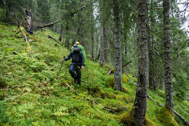
Well, after a rest day, it was time to move our asses further down Sæterdalen. This day was quite tough as we walked through untouched forest that was quite dense = lots of branches in the face. This day we were heading for Lakselvvatnet (Salmon river water) with the hope of catching some salmon!
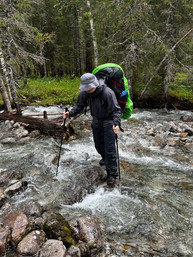
The route had multiple river crossings, a lot of them could be done without switching to crocs. But one of them we had to wade. This bigger river that we had to wade ended in a waterfall, so I made the very smart move to drop my trekking pole while crossing and taking some video for my YouTube video of the trip. I could see the trekking pole quickly disappear downriver. We tried to find it, but most likely it had fallen down the water to Sæterelva and the onwards to Lakselvvatnet. So I guess my trekking pole got there before me, that is very much a first...
At some point, we reached the Sæterelva and just continued along the river, which made progress a bit easier. It was steady progress until we reached Lakselvvatnet. We wanted to go to the place called "Neset" a piece of land sticking into the lake. Well, on the south side of there are vertical cliffs down, so we had to walk in the lake... As you can see on the last photo it was a bit weird, but it worked; the water went to the stomach, so it got quite a lot worse than the photo.


On our way to Lakselvvatnet. Last photo shows Lorenzo walking in the lake (not on it though, so we can conclude he is probably not Jesus - maybe closely related though)
We reached the destination; it was a nice place, so we decided to stay there for one more day, also to maximise the chance of catching a salmon. At this point, I should maybe mention that I am the only one with a working fishing rod left. One lost his rod in Henriksdalen, and the other broke the end of the rod on a tree while hiking (protect your rods, everyone).


Camp at Lakselvvatnet
After trying to catch a salmon for two days and catching nothing, I decided to spit in the lake and continue on from the lake with a very misleading name...
This day was a day that turned from not that long to very long. We started off heading for Laksmarkvatnet but ended much further south... The first and very BIG problem was crossing lakselva, the place we crossed it was 60 meters wide and still quite challenging, lots of current, wet rocks and depth to around the stomach. Fortunately, we managed to get over no problem! And on other side of this crazy river there was a trail that we could follow and get to our destination quickly.

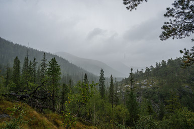
It did not take long before the trail got less and less like a trail and more like just hiking without a trail :() Which meant the fast progress was not so fast after all. To add some more to the challenge, it began raining A LOT.
We reached Laksmarkvatnet, but the campsite choices were bad, and in some very moist places. So we decided to continue on towards Tøymvatnet where there is a hut. The hut would be a dream to reach because we were quite wet, and it would continue to rain for multiple days, so we could dry and chill in the small hut.
We continued on, and quickly, my internal inclinometer began swinging a lot to my right side. Somehow we had ended up walking on a steep slope that went straight down ot Laksmarkelva... With careful manoeuvring, we managed to overcome this small challenge.

After a long time of hiking in the heavy rain and just being extremely tired, we just ploughed through the last river crossings with boots on - no energy or time for switching back and forth to crocs. In the end, after a challenging crossing of the river feeding Tøymvatnet (probably had high water because of the crazy amount of rain that had fallen), we reached the hut. What a relief... Cold and wet, we went inside and the very generous people who had been there before us had left it so that you could start the wood stove by just taking a match and lighting the birch wood. Very nice, we of course also left it that way.


Walking to the hut at Tøymvatnet. A very wet trip.
We stayed at the hut for two days, fishing and just keeping nice and warm. We had good success with the fishing!


Staying in the hut and making deep-fried fish!
It was hard to get going again, but we just had a short trip in front of us to Langvatnet. The trip was easy and we found a cool half-island to pitch the tents, great spot for fishing also.

At Langvatnet we spent an extra day; it was a nice place with good fishing and views.


Day at Langvatnet. Yes, I like photographing my very beautiful tent, a Hilleberg Allak 2.
In the evenings, we fished with good success. Around sunset, the fish became very active, and it was pretty easy to catch them! Only downside is that you have to gut them in the dark... We let them hang (after gutting) till lunch the next day, which worked quite well, and it tasted good with mashed potatoes.
After the nice days at Langvatnet, we continued to the end point of the trip, Storbørja. It was a nice trip and we actually had some okay trail for some parts of the trip. Most of this part was technicaly outside the national park, but it still felt pretty wild. The mood was good, but we were a bit sad that the trip was ending now. On the other hand, we were looking forward to going crazy in all kinds of food when we reached civilisation!


Last hiking day of the trip.
The last evening was spent fishing in the sea, with great success, 8 fish in 1 hour! Not big fish, but still fun! In the morning, we were picked up by Velfjordskyss, and we stayed at their campsite. They were really nice to work with!


Last evening + sailing out next day
This was a great adventure, this place has it all: fjords, valleys, peaks, rivers and good fishing! I will be coming back sometime. Maybe when I walk the length of Norway.
If you know what you are doing, this is a great place to hike. It is not beginner-friendly and we did not have any phone coverage on the trip - except just the start, so an InReach is a good idea.
One more thing, you may call it gatekeeping, but let's not make this place too popular by telling everyone in every Facebook group or on Instagram about this place. I have been to Femundsmarka, where you can really see that humans have impacted the wilderness; this is also becoming a thing in Sarek.
Please comment any questions. Also please give me some feedback as I am very new in this game. If you or your company wants to work with me, then use my contact formular.

Thanks for feading!

Kommentarer